Saturday, May 31, 2008

Hike #17 Mount Baldy on May 29, 2008


Ok. I decided to end my hiking routine with a monstrous attempt. Keep in mind that I am horribly out of shape so to accomplish this is very encouraging to myself. Mount Baldy is actually Mount San Antonio but it got the name of Baldy because the very tip appears to be bald from the lower elevations.
I started my hiking this year in April at a hefty 275 lbs. Now here it is June and I'm sitting just under 230 lbs. Unfortunately I have to stop the hiking for a while because both of my knees are worn out and I can now barely walk. So... I'll be losing some more weight by alternative means for a month or two and hopefully I can get my weight down to 200 lbs. before I start to hit the trails again.
The climb to Mount Baldy was very enjoyable and it is one that I will most definitely be doing again in the very near future.

Monday, May 26, 2008

Hike #16 On May 26, 2008 Mount Lowe Railway Loop Tour

Finally the rain has left us and I can once again commence my assault on the hiking trails. No photos on this one as I left my camera at home. This was quite the punishing hike at 12 miles but it was well worth it. I give this hike an 8 out of 10. The two negatives of this hike are 1) overuse and 2) lack of wildlife on the trails. There weren't even that many birds to be seen.

Visiting the old Lowe railway was quite the step back into history. I was gripped with sadness to know that we have lost this Altadena gem forever but at the same time very thankful for the preservation of the past for those who want to take a walk into the pages of history.

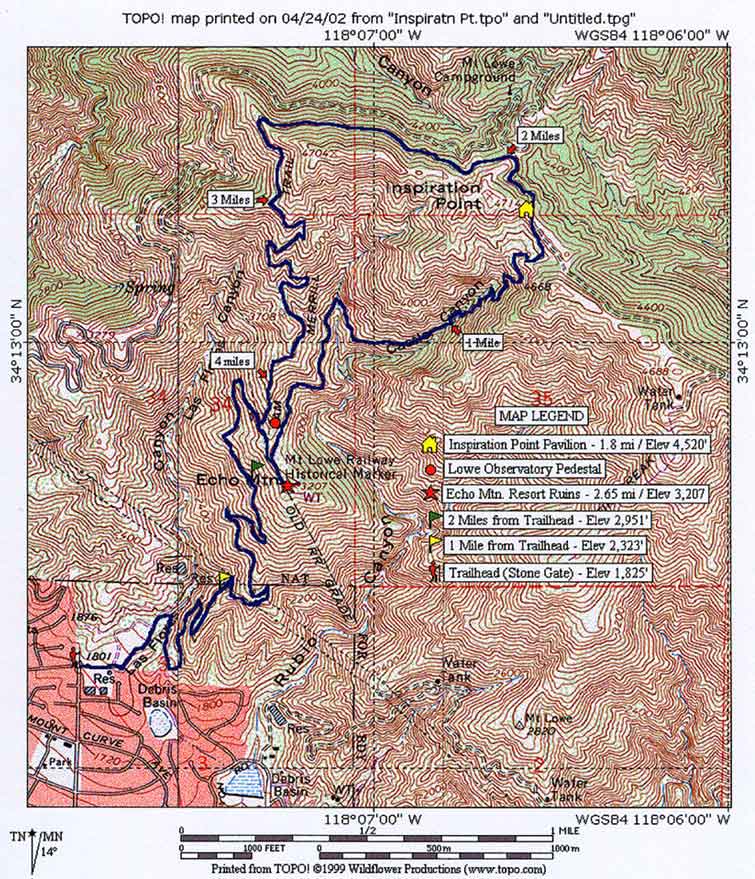
The route that I went was by parking at the end of Lake ave. in Altadena and walking the entrance to the Cobb estate and then proceeding up the Lower Sam Merrill to Echo Mountain and then a little jaunt up Echo Mountain trail to meet up with the Sunset Ridge fire road. I then followed the fire ridge road all the way to Inspiration point and then I went down Castle Canyon trail to meet up once more with Echo Mountain trail and then I returned the way I came buy climbing back down the Lower Sam Merrill.

My knees were shot at the beginning of Castle Canyon Trail and the return hike was very painful. I think I'll be resting my legs a bit over the next day or two and then I'll probably look for a few hikes in the 3 to 5 mile range to close out my week. I want to try and make at least 3 more hikes this week as this hike burned at least 5 pounds and if I can continue with a few more hikes it will push my weight down probably by another 5 to 10 pounds this week.

Here are a few links on Mount Lowe is you are interested in doing a little bit of research before the hike.
1. Dan Simpson's notes on his Echo Mountain hike.
2. Mount Lowe Historical Society.
3. Topo Mount of the area compliments of Dan Simpson.

Tuesday, May 20, 2008

Hike #15 Dawn Mine on May 20th 2008


Ahh.... found it on my second trip. No doubt I'll be doing this one again once I'm in a little better shape and I have a rope and a headlamp. As it is I went in fairly deep exploring the mine. There are some very deep holes in here so I was somewhat cautious. The trail to the mine that I took was the straight northly route. My problems didn't manifest until I took the east route to the fire road. Man that was a dangerous return trip. I lost a few supplies above the Millard Canyon falls area and I slid down the uppermost part of the falls for about 75 feet or so. Fortunately I only came away with a few bumps, bruishes, algae and animal crap on me from the fall. This is one of those must hikes that should be reserved for those days when you just don't want to go into work and it is partly cloudy outside as it was today. I wish I would have had a hiking buddy with me on this one to talk me out of a few bad turns and maybe to talk me into staying more time exploring the mine. Next time hopefully I'll have some rope,head lamp, and slickers for exploring all of the mine that I possibly can.

Monday, May 19, 2008

Jobless

Once again I find myself jobless. This time I see it as a plus. I can focus more on my hiking than ever before. Tomorrow I am planning to do some more hiking in the Lowe Railway area and Wednesday if they weather is favorable enough I'll do the 10.5 mile Coldwater canyon hike. After that I am planning Sunset Peak and Mount Baldy by this Friday if all goes well.
Oh yeah, my job plans? Something other than direct computer support. Maybe a manual labor job or at least a job in the great outdoors. Construction is definitely an option but I am hoping to find something in the venue of tree trimming or landscaping. That should keep me burning the calories.
The good news is that I don't care this time. I guess some would say that I have a bad attitude but really a job is to serve me not me to serve the job and that is the way I see it. If I put in more than I can ever get out it better be for something that I really care about or have a passion to see grow.

Saturday, May 17, 2008

Good Links About Hiking and What Not

http://www.inciweb.org/incident/1263/ information on fire conditions this link goes specifically to the big horn fire that as of this posting is still active at Mount Baldy region.
http://www.on-the-loose.org/guide.php?p=backpacking site maintained by a college about local hikes
www.localhikes.com great resource for hiking just about anywhere.
www.simpsoncity.com/hiking The best on line hiking journal that I have found

Friday, May 16, 2008

Hike #14 Millard Trail Summit May 16.2008


Ok. This hike was supposed to be a hike to the Millard Gold mine but I went right instead of left at the cabin and wound up about 1.5 miles off course. I did get an interesting view from the summit of Downtown Los Angeles though. Total trip time was 4 hours and the distance was a little over 6 miles. The temperature in Pasadena was over 100 so coming back from this hike was pretty darn miserable, but since I was hiking it was still better than anything else I could have been doing.

Hike #13 Big Pines Area May 14-15


I decided to head up to Big Pines area just west of Wrightwood on the 14th of May to knock out the 4 hikes that are listed in Jerry Schad's book Afoot & Afield in Los Angeles County ( here at amazon ) for the Big Pines area A-14. There are several more hikes to do up there besides those and I will return to accomplish at least the one mentioned in Robinson's book (this book) as well.
It was a beautiful couple of days for hiking and strolling through the large Jeffrey Pines was quite the treat for me. I did tire a bit earlier than I had expected and headed home early on Thursday after also stopping and walking the mormon rock park in San Bernadino County. Overall a very enjoyable 1 and a half days of hiking. Oh yeah, my blue ridge trail hike ended at about 9:00 p.m. so it was my first hike in the dark... good thing that I set up my tent before heading out on the trail.

Friday, May 09, 2008

Hike #12 Cattle Canyon


Another hike today. I got three in this week. I think I'll go for broke and try to hike every day next week if my feeble body can handle it.
I went on a hike down Cattle Canyon road which starts in the Sheep Mountain Wilderness right next to the old bridge on East Fork road in Azusa. Total hike distance is around 6 miles and this hike required 3 hours to hike. Not a bad time at all considering that this is a boulder hopping, stream splashing kind of a hike. If it wasn't for seeing the Western Tanager I doubt that I would ever do this hike again. The canyon is filled with graffiti and way to many stream crossings.
I can understand someone tagging with graffiti in a city, and in fact, some places I have come to expect it living in the Los Angeles area but what purpose or intent does it serve to tag in the middle of the forest? Sad sad sad is all I can say.

Wednesday, May 07, 2008

Bridge To Nowhere hike #10


Hiked Bridge to Nowhere on Tueday the 7th. Pretty good hike although from all that I have heard about this hike I expected a very well maintained trail. The exact opposite was in effect, there were multiple river crossings and the trail for the most part was non existent. Total hike distance was 10 miles and the time duration was approximately 6 hours.

I encountered 2 rattlesnakes and 1 very large garter snake. One of the rattle snakes was between 6 to 8 feet long and I nearly stepped on the thing.